Analysis Highlights - November 2022
Contaminated Lake Sediment Assessment
State of Michigan EGLE personnel collected 39 sediment cores in the harbor in the summer of 2019. The cores were analyzed for PCBs, heavy metals, and grain size by ALS Environmental, Holland, Michigan. The 175 individual assays from the 39 cores represented surface sediment down to a maximum of nearly 5 feet in depth and indicated the surface sediments (0-2 inches) showed no PCBs detected with the exception of one at the new Douglas marina. The surface value detected was well below the regulatory limit of 1 ppm. Only two sites in the harbor had PCBs concentrations above 1 ppm in the top foot of sediment (both in the 6-12 inch assay).
Bottom line: There is no or very little risk of PCB exposure from lake sediments in our harbor.
Kalamazoo Lake Harbor Surface Water Contamination
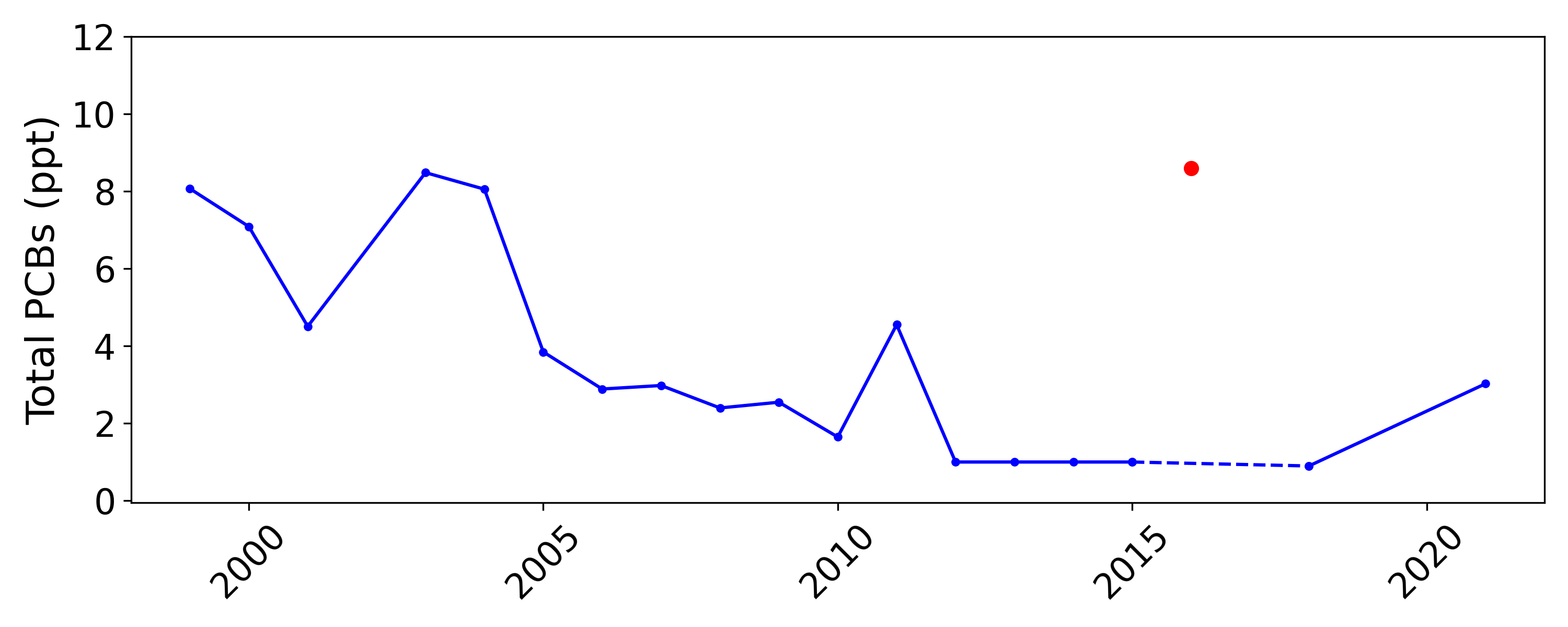
State of Michigan personnel (DEQ/EGLE) have collected water samples at the Blue Star Bridge from 1999 to 2021 for the purpose of monitoring PCBs in the harbor water column. The time series was analyzed by MTRI. The EPA Maximum Contamination Level (MCL) for PCBs in drinking water is 500 ppt. Observed PCB levels decreased from 1999 through 2018, with all observations well below the EPA 500 ppt MCL. A moderate increase in PCB levels was observed in 2021, possibly related to upstream dam removal activity.
Bottom Line: The water in our harbor is safe to recreate in, but water sampling should continue to ensure its safety.
Sediment and Water Column Contamination
In 2019, the Michigan Tech Research Institute (MTRI) was awarded a grant by the Michigan Department of Natural Resources (MDNR) to characterize the hydrology of Kalamazoo Lake and Harbor in support of recreational boating. Part of the project included a comprehensive re- sampling of PCB sediment contamination in the region, providing an update to the last such effort which was undertaken in 2000.
Sediment sampling took place between July 15 and 19, 2019. Sediment cores were collected from 39 sites and split into a total of 175 samples representing specific depth increments. PCB contamination levels were analyzed at ALS Environmental in Holland, MI. Total PCB concentrations were evaluated against the regulatory limit of 1 part per million (ppm) established by the EPA’s Toxic Substances Control Act (1976).

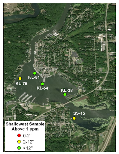
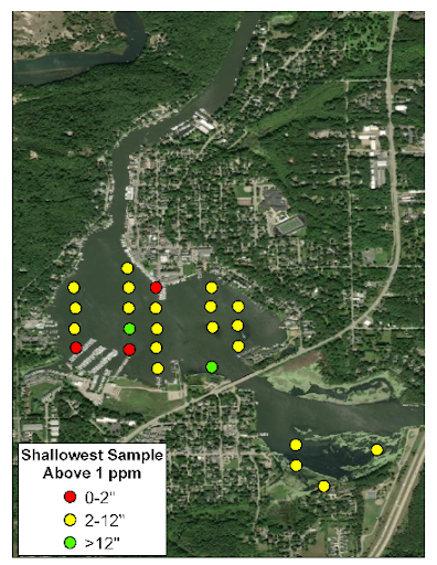
Of all the sites sampled in 2019, only one (SS-15, located off of Wade’s Bayou Memorial Park in Douglas, MI) had detectable PCB concentrations in the top 2 inches of soil and that concentration was well below the regulatory limit. None of the sampled sites had concentrations above 1 ppm in the top 6 inches of sediment. Only five sites had PCB concentrations exceeding the regulatory limit anywhere in the sediment depth profile: KL-38, KL-54, KL-61, KL-75, and SS-15 (see Figure 2A below for the locations of these sites). In contrast, the sampling effort in 2000 revealed 25 sites where concentrations exceeded the regulatory limit. Of these, three had elevated concentrations within the top 2", at sites adjacent to Sergeant Marina and Tower Marina.
Of all the sites sampled in 2019, only one (SS-15, located off of Wade’s Bayou Memorial Park in Douglas, MI) had detectable PCB concentrations in the top 2” of soil and that concentration (0.160 ppm) was well below the regulatory limit. None of the sampled sites revealed concentrations above 1 ppm in the top 6 inches of sediment. Only five sites had PCB concentrations exceeding the regulatory limit anywhere in the sediment depth profile: KL-38 (12-24”: 2.1 ppm), KL-54 (24-34”: 3.96 ppm), KL-61 (12-24”: 1.2 ppm; 24-36”: 1.3 ppm; 36-48”: 3.2 ppm), KL-75 (6-12”: 1.2 ppm), and SS-15 (6-12”: 1.3 ppm). The locations of these sites can be seen in Figure 2A. Figure 2B shows the 25 sampling stations from the 2000 sampling effort where the PCB concentrations in at least one of the depth samples exceeded 1 ppm. Across sites sampled in both 2000 and 2019, the 2000 sampling effort had three sites with concentrations above the regulatory limit in the top 6 inches, and two within the top 2 inches, both in the vicinity of the Tower Marina docks.
 Figure 2A
 Figure 2B
Vertical soil profiles of PCB contamination can show how deep the concerning sediments lie beneath the surface. Comparing the profiles from 2019 with the profiles from 2000 can show if the contaminants are being buried deeper, and therefore are of less concern for those recreating in the lake. Of the five stations where PCBs exceeded 1 ppm in 2019, four were also sampled as part of the 2000 effort and they all exceeded the regulatory limit then as well. The PCB concentrations were generally higher in 2000 and the elevated concentrations have shifted deeper beneath the surface as new sediment from upstream is deposited on top of the contaminated sediments (Figure 3). Site KL-75 is the exception, with no deep PCB contamination layer in 2019. This site is located along the dredged path from Lake Michigan to Tower Marina, so the deeper contaminants observed in 2000 may have been removed in the dredging process.

Using bathymetry maps collected in 2006 and 2018, a map was made showing where sediment has accumulated within Kalamazoo Lake (Figure 4, below). Most of the lake showed accumulation of less than 1 foot in that time, but a region in the eastern half of the lake accumulated up to 3 feet of sediment. Once buried, sediment does not typically re-surface unless it is dredged up.

In addition to the sediment sampling efforts, surface water samples were collected and analyzed for PCB concentrations from a site near the Blue Star Highway overpass (42.648, -86.199) multiple times in most years from 1999 through 2021. The mean annual PCB concentration was calculated and assessed to investigate change over the sampling time period. In the case when no PCBs were detected, the concentration was set to equal the minimum detection limit (0.2 ppt for 1999-2011 and 1 ppt for 2012-2015). The EPA maximum contaminant level (MCL) for PCBs in drinking water is 0.5 ppb (500 ppt) and 0.17 ppt for streams and lakes from which people drink water or eat fish, however the goal is for zero contamination.
The mean annual concentration of surface water PCBs from 1999 through 2021 is shown in Figure 5 below. The observed concentrations have generally declined since the early 2000s, with one notable exception. In 2016 (marked in red on the figure below), the average surface water PCB concentration was 8.6 PPT across the two sampling dates, however both samples also indicated “Non Detect”, suggesting a potential issue with the data. Note that from 2012-2015 and in 2018, the mean concentration appears constant at around 1 PPT. For 2012, 2014 and 2015, there were no samples that detected PCBs and in 2013 only 2 of 9 were able to detect any contamination. A different analysis method was used in 2018, with both samples detecting PCBs with concentrations just below 1 PPT. A slight increase in concentration was observed in 2021, which may be related to dam removal activities upstream. All measurements were well below the 500 ppt MCL for drinking water, but could not be assessed against the 0.17 ppt standard due to the minimum detection limit for the tests.

In summary, PCB concentrations in the sediments and surface waters of the Kalamazoo Lake region have greatly improved over the last 20 years. None of the sampling stations visited in 2019 had concentrations exceeding regulatory limits in the top six inches of sediment where they are most likely to be re-suspended into the water, and only five had elevated concentrations anywhere in the sampled profile. Where the 2019 sediment samples did contain elevated PCB concentrations, they had been shifted deeper due to sediment accumulation from upstream, reducing the likelihood of human exposure. . The surface water PCB concentrations have also been steadily declining since 1999, but should continue to be monitored as upstream dam removals continue.
A PDF version of this content can be viewed here.
Contact Karl Bosse for full PCB contamination results from 2019.